The Sukha Spit is a young coastal accumulative landform located in the southwestern part of the Kinburn Peninsula (Black Sea). The formation of the spit began in the early 1980s under the influence of several natural factors, including the accumulation of coastal and marine sediments, the impact of aeolian processes, and the stabilization of the spit’s surface by vegetation cover.
This study aims to analyze the morphodynamic and spatiotemporal parameters of the Sukha Spit’s development, as well as to determine the characteristics of its surface stabilization by vegetation cover.
The research utilizes regional aerial photographs from 1983–1984, satellite images from Landsat (1975–2010) and Sentinel (2016–2025), as well as data from hydrometeorological databases. Spatial analysis was conducted in ArcGIS using classification methods (water, sand, vegetation), indexing (NDVI), shoreline vectorization, and the calculation of accumulation rates based on time-series data.
Over its 45-year evolution, the total length of the Sukha Spit has reached approximately 4.5 km, indicating its continuous progradation in a southeastern direction. However, retrospective remote sensing analysis suggests that the spit’s development follows a staged process, influenced by the hydrodynamic conditions of the adjacent water bodies.
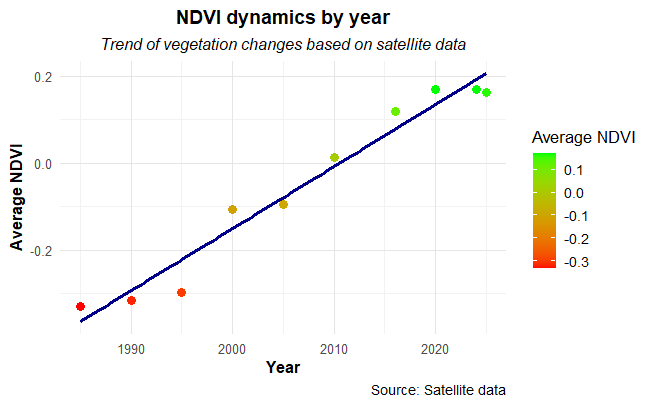
Vegetation cover began forming a few years after the stabilization of the spit’s basal sandy deposits, initially concentrating in the most sheltered areas on the leeward side of the spit, particularly on the surface of aeolian landforms. NDVI analysis revealed a gradual increase in vegetation biomass since the 1990s (Fig. 1).