
Ocean fronts are sharp boundaries between different water masses and different types of vertical structure (stratification) that are usually accompanied by enhanced horizontal gradients of temperature, salinity, density, nutrients and other properties [1]. Fronts and the associated currents play important roles in heat and salt transport, ocean-atmosphere interaction and ecosystem functioning. They are well known as contributors for elevated primary production areas, which are known as "hot spots" of marine life, from phytoplankton to apex predators. Moreover, the surface convergence can also lead to higher concentration of pollutants [2].
The main aim of this research is to analyze the distribution and alternation of hydrological fronts in the Baltic Sea. As fronts are high-gradient zones; therefore most objective computer-approaches to front identification are based on gradient computations. The approach used in this study is based on histogram analysis and Single Image Edge Detection (SIED) algorithm. Since a front is a boundary between two relatively uniform water masses, histograms of any oceanographic characteristic (e.g. SST) in the vicinity of the front should have two well-defined modes that correspond to the water masses divided by the front, while the latter corresponds to the frequency minimum between the modes (Fig. 1a). The front detection and tracking is conducted at three levels: window, image and pixel. The optimum window size found by Cayula and Cornillon [3] is 32 by 32 pixels. The front detection algorithm uses all pixel-based SST values within each window to compute a SST histogram for the given window. For each window that contains a front (a relatively narrow zone of enhanced SST gradient), the corresponding SST histogram would have a frequency minimum identified with the front [4].
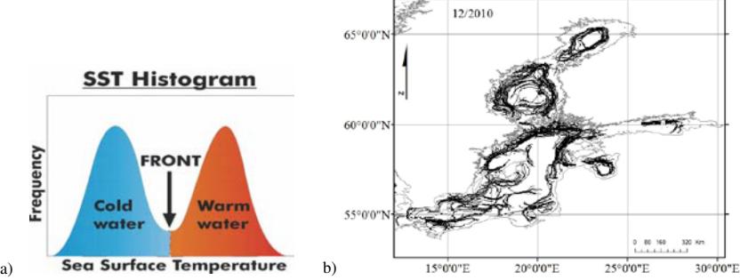
To get a representative front distribution over the whole Baltic Sea area, it was made a composition of a few days. Numbers of images composited show us the stability and temporality of fronts. It is apparent that fronts occur much more frequently in certain areas compared to other. The large-scale distribution of fronts is aligned to the coast and follows the local bottom topography – along the Eastern Gotland basin extending north to the Western Estonian archipelago, Western Gotland basin, eastern coast of the Bothnian Sea, and in the Gulf of Finland along its northwestern coast extending southwest through Northern Baltic Proper to the coast of Sweden (Fig. 1b). Most of these fronts are distinct year-round. While others (beside Gulf of Riga, Pomeranian Bay, and Gulf of Gdansk) are frequent under the influence of a very strong stream of freshwater of rivers. Moreover, other small-scale fronts are found in the Arkona basin and Irbe Strait due to connection of two different basin with low or high salinity water.