
A brief overview of severe weather phenomena such as very heavy rain and very strong squalls over Lithuania in the last 60 years (1961–2020) is presented. Synoptic and climatological analyses of 218 cases with rain (≥50 mm/12 h) and 38 cases of strong squalls (wind speed ≥28 m/s) from April to September (for squalls) and to November (for rain) were examined. All data used for research are taken from Lithuanian Hydrometeorological Service (LHMS) archives.
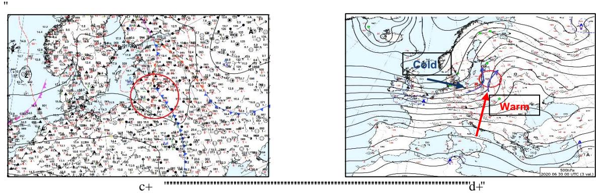
Extremely heavy rain and powerful squalls mainly develop in warm season. The synoptic situation favourable these severe weather phenomena to occur is formed usually by influence of the North Atlantic Ocean, Mediterranean Sea and Black Sea. Firstly, the Atlantic opens paths for wet and mild airmass, which merges with dry and warm continental airmass and due to big temperature and humidity contrasts creates instability in the whole column of the atmosphere over the country. Atmospheric convection becomes especially active when a warm upper ridge over the northern part of Ukraine, or western part of Russia, is replaced by cold trough moving from W/NW Europe or Scandinavia and pushing the heat eastward (Fig. 1).
As a result, it was determined that 1/3 of heavy rain cases formed by passage of cold airmass: cold or secondary cold fronts (17% of cases) and cold wavy atmospheric fronts (15 % of cases). Respectively, synoptical situation leading to the development of squalls in Lithuania is following: S/SE troughs from Scandinavian cyclones (39 %) and cold waving fronts (16%).
Secondly, the results of analysis of the southern-southeastern flow at 500 hPa height from Mediterranean and Black Sea show that tropical airmass dominate in 27% of cases with heavy rain and 16% of cases with squalls, warm and occluded atmospheric fronts prevail in 23% of rainy cases.
Short range heavy rain (<3 h) and squalls associated with lines of convergence in tropical airmass and are predominant at day and evening; long lasting rain (11-12 h) associated with warm and occluded fronts are more often at night and morning.
Rain with 50-65 mm is prevailing (74% of places with rain), squalls with wind gusts 28-32 m/s predominate in 86% of all registered places with squalls.
In fact, on an average 4 heavy rain events per year, and 1 squall per 2 years registered in Lithuania. Considering to squalls locality, the real number of occurences is higher: it is to be supposed near to 2–4 very strong squalls per year.
The areas of distribution of both phenomena in Lithuania are different: heavy rain is more often phenomenon in the NW regions, strong squalls – in the SW and NE parts. It is hard to avoid subjectivity in squalls observations. Obviously, it is a good correlation between density of population and number of squalls – the more people use technics (mobile phones, cameras etc.), the more events they report to LHMS or media.
Increasing of intensity of extreme weather phenomena is one of the features of climate change impact in the Baltic region. To provide more clarity, mean annual temperature and precipitation anomalies and trends as symptoms of climate change are presented in the poster.